Thursday, October 13, 2016

Cache Register

Since our illustrious editrix decided to play word games with my last post about caches, a few of the writers here have decided “challenge accepted”. You want prepper puns? We'll deliver them.

If you're going to hide some things far away from your normal Area of Operations (AO), you'll need to have a way to find them when you need them. A map with a large red X on it will work, but it will also mark the spot for anyone else that may see or find your map. I mentioned encrypting the location information in my last post, so here are a few methods that will work toward that end.

Methods of Identifying a Location
First, you need to figure out what kind of information you're trying to hide. The location of a cache (buried, submerged, or otherwise hidden from view) can be expressed as a series of numbers and/or letters using one of many methods. Those letters/numbers can then be encrypted to make it more difficult to find your cache.

Latitude and Longitude
The most common method of designating a specific place on the planet, lat/long has been in use for centuries. Starting from the arbitrary “zero” of the Prime Meridian that passes through Greenwich, England and moving around the earth east and west, we divide the world into 360 one-degree slices. The north-south division begins at the Equator and is also a total of 360°. Each degree is divided into 60 “minutes” (symbol ' ) and each minute is divided into 60 “seconds” (symbol “). A complete lat/long would look like 21 18' 32 ' -157 51' 3” or 21.308787 -157.850811 in decimal form. The negative sign designates areas south of the Equator and/or west of the Prime Meridian. Geo-caching and modern GPS units have made lat long a common system.

Military Grid System
Instead of working with pure numbers, the US military decided to separate the Earth into 60 east-west zones (numbered 1 through 60) and 20 north-south zones (letters C through X, excluding I and O which are easily confused with 1 and 0). Each block designated by a number and a letter is roughly 6° by 8° and covers about 800 km by 1100 km. An example zone would be called “4Q”.

Each block is further split up using 24 east-west and 24 north-south lines, to create squares. These squares are identified using the same letters of the alphabet as the grids. An example would be “FJ”.

Locations within the squares are pinpointed by measuring, in meters, from the south-west corner. You measure the distance east, then the distance north to get a string of numbers. The more precise the location, the more numbers. An example would be “19056562”, which means 1905 meters east and 6562 meters north of the starting point.

Using this system (which takes some practice) and military maps, a chunk of land 10 meters on a side would have a designation something like “4QFJ19056562”, which happens to be somewhere in Honolulu, HI.

Polar Coordinates
Instead of measuring in squares, another method uses vector and distance from a known point. If you have a standard starting point, say a large boulder or a bridge, you take out your compass and note the direction to your cache (the vector). You then measure the distance in paces, meters, feet, etc. and combine the two. An example would be 143275, for a point 275 meters (or feet, whatever you want to use) from your starting point at a bearing of 143°.

Encryption
Now that you have your data, you need to pick a way to hide or encrypt it. I don't have the time or space to get into all of the possible ways you can encrypt numbers, but I can give you a few basics.

Substitution Codes
These are the most common form of encryption. Replacing a letter or a number with another digit, chosen through a system that only you know, is the root of a substitution code. They are as basic as replacing the numbers 0 through 9 with letters of the alphabet starting with the first letter of your middle name (FGHJKLMNPQ for me) and get as complicated as the 128-bit security algorithms used for banking. Pick one that you're likely to remember or that you can pass on to someone else if you're unlikely to be able to use your cache. Replacing letters with numbers is similar. I suggest you look into one-time pads if you're serious about encrypting data.

Steganography 
Another method of hiding or encrypting your data, the quick definition is "placing your numbers and/or letters in an existing document in such a way that they are not noticed" (follow the link for a thorough explanation). Writing your debit card PIN number down as the last four digits of a phone number is a (not very smart) example - anybody that sees it will think it is just a phone number. Writing a lat/long designation in decimal form down in the back of a math book, maybe as part of an equation, would be another example.

Split Control 
This option breaks your data into two parts and gives each part to a different person. John has the longitude or vector, but Mary has the latitude or distance.


Being able to find what you have intentionally “lost” is important. I hope I have given you some things to think about, and maybe a new idea or two. As always, comments here or on our Facebook page are always welcome.

Wednesday, October 12, 2016

Prudent Prepping: GHB Tune-Up

The dust has settled and the First 72 Hours have passed. Follow along as I build a long term plan via Prudent Prepping.

My boss has moved me to a different territory, which more than doubles my mileage and comes close to tripling my commute time since I will be traveling through major cities and crossing bridges every day. Now I have to configure my Get Home Bag for being away from home for more than two days.

Changes In My Get Home Bag 
In last week's post, I mentioned a long sleeve t-shirt being added. That is now supplemented with extra wool socks, a full pack of Esbit fuel tabs for the stove, 4 liters of water (counting the two in the truck) and extra packets of coffee. I normally have about 4 days of food in the pack; if I don't have time to pack a lunch, I eat the soup/chili or tuna and crackers, plus whatever leftover condiment packs I get when I'm out. (Don't judge me, I'm single.)

GHB Contents:
As it gets colder, I will be adding one long sleeve Polypro t-shirt to the mix and possibly an insulated vest that will be kept in the truck. It gets damp and a bit cold near the ocean here.


Just a reminder: if you plan on buying anything through Amazon, please consider using our referral link. When you do, a portion of the sale comes back here to help keep this site running! 

If you have comments, suggestions or corrections, please post them so we all can learn. And remember, Some Is Always Better Than None!

NOTE: All items tested were purchased by me. No products have been loaned in exchange for a favorable review. Any items sent to me for T&E will be listed as such. Suck it Feds.

Tuesday, October 11, 2016

Cache Flow

Sometimes, you need to stash things. Sometimes, the place you want to stash your stuff is wet, either part time or full time. With a little work, these locations can prove ideal.

Wet locations have quite a few things going for them, in regards to hiding a cache:
  1. Their usually cool nature can extend shelf lives on some items. 
  2. They're usually less accessible than dry areas, discouraging thieves and scavengers, who may not even think to check for a watery cache. 
  3. Sealing your cache to keep it dry also keeps smells from getting out, which will prevent animals from locating and destroying your supplies.
Wet caches do have some drawbacks, though:
  1. That inaccessibility that keeps them safe also can impede your access. For example, getting to a watery cache in December might be trivial for Erin, but ice and snow might make it almost impossible for me. 
  2. Also, water getting to your supplies can damage or destroy them, rendering the cache worthless.
If you are going to sink a cache, the two big problems are keeping it dry and keeping it down. Using a length of PVC pipe to contain your cache puts you on the road to solving both of these problems. Other cache containers will work, but will require some testing before you trust them with anything critical.

Making a Watertight Cache
  1. Consider the largest items you plan to cache when sizing your pipe. Make sure you have sufficient pipe length and diameter to hold these items and anything else you're planning on stashing. 
    • Vacuum sealing items in your cache and including desiccant packets are also good ideas.
  2. Use PVC cement to seal one end of your pipe with an appropriately sized pipe cap and allow it to dry. Do all of your gluing in a well-ventilated area, as PVC cement smells terrible and is generally nasty
  3. On the other end of your cache pipe, glue on a female threaded adapter. This, combined with a threaded plug, allows access to your supplies. 
  4. A bit of thread sealant whenever you remove and replace the plug should keep the contents dry.
As a side note, everything linked to in this article is 4" material, because that is a convenient size for general storage use. Larger and smaller sizes are available at your local store, for larger and smaller prices.


Dive! Dive!
Now that our things are dry, we need to make them sink. How easy or difficult this is hinges upon how heavy your supplies are. A heavy cache won't need much help staying down, but a light cache will need all the help it can get.
  1. Adding weight to a light cache is a good way to get it down; a handful of steel hardware (nuts, washers, screws, etc.) will always be handy in supplies, in addition to adding weight. 
  2. Caches also need to be anchored in place, so epoxy or otherwise attach a length of cord (paracord works great) to the side or end of your cache, then tie or otherwise secure it wherever you'd like your cache to stay. Shorter lines are less subject to fouling, and keep your cache in one spot, but use whatever length fits your needs. 
  3. Mark or otherwise note your cache location, and you're good to go, knowing your stuff is safe and in a very inconspicuous location.

Lokidude

Monday, October 10, 2016

Hurricane Matthew: the Cleanup

Not actually Erin.
& is used with permission.
This ought to be the last Matthew post I do, thank goodness.

After a great stay in Atlanta meeting with friends of the blog and podcast, I packed up and drove all day, arriving home around 1 am. (This is why there was no post yesterday and why a post written on Tuesday is being back-dated to Monday.)

Driving home was uneventful save for the last few miles, where branches had been blown off trees and were sticking out into the right-hand lane. Fortunately for me, I saw them in time and they were easy enough to avoid, but someone who was not paying attention (or who had trouble seeing dark objects by the side of the road at night) might hit them and damage a tire.

My family is in good health (including my dogs) and the house is in remarkably good shape. I haven't yet gone up on the roof to check for missing tiles, but here is the extent of the damage so far:


Our old TV aerial was ripped out by the mounting bracket. We hardly used it, but it was a nice backup to the dish when weather interfered with satellite connection.


It fell and hit this tree, hurting it severely. This is rough on mom because she plants a new tree every time one of our dogs died. This is Shadow's tree. (He was a purebred black German Shepherd, 1996-2006. Shadow was a Good Dog.)


You can see where the wind did a number on the trellis behind the yard light. The light itself isn't working due to water damage; when the trellis fell, it tilted the light cover up and exposed it to the elements. To avoid potential shorts or electrocution, we aren't using it until it's looked at by an electrician.


Today is trash day. Our usual load is two bins and a trash can; everything to the left of the trash can is "yard trash": leaves, branches, etc that were blown off our trees, or into our yard from elsewhere.

We got off light for three reasons:
  1. Matthew was a Category 3 when it hit ut
  2. The eye never made landfall
  3. We live 8.5 miles from the ocan. 
But the beachside took a total beating. Take a look at these:


http://www.firstcoastnews.com/news/local/hurricane-preparedness/flagler-beaches-closed-indefinitely/332343145

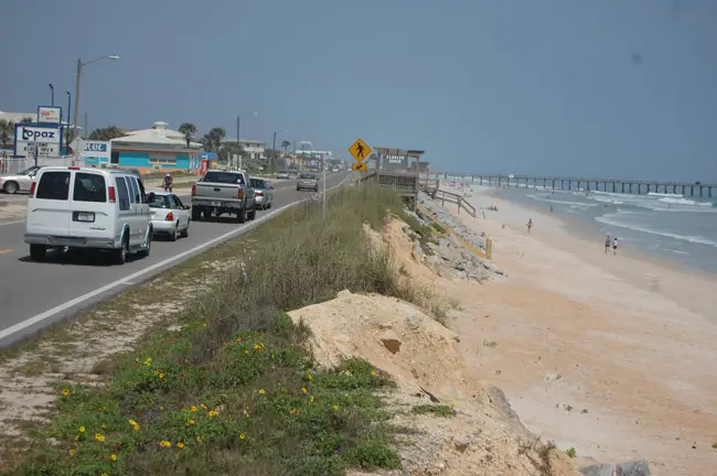
What you are looking at is State Road A1A, which parallels the ocean from Key West to Georgia, undermined to its centerline. This is doubly impressive when you learn that the topography isn't just "road, then beach". Here's a pre-Matthew picture of the same approximate view as the above picture:

http://flaglerlive.com/wp-content/uploads/a1a-12th-street.jpg

What you have there is room for a car to park on the shoulder, followed by a hammock, followed by coquina rock. Combine that with a 12-foot width of an American traffic lane, and this means that Matthew scoured away at least 36 feet of rock, sand and soil during its stay here.

Remember, Matthew was a Category 3 and did not make landfall. Imagining what would happen if it had come ashore at a Category 4, I'm thinking that A1A would have just ceased to exist. Right now, the damage to both Flagler and Volusia counties is estimated at $425 million and climbing. They're probably going to try to restore the beach to its original condition, and I'm just thinking How about a nice concrete sea wall?

http://www.news-journalonline.com/news/20161008/food-water-available-in-flagler-for-hurricane-matthew-victims

Finally, here is a picture I took of the gathering storm clouds Wednesday night, the day before I evacuated. Pretty, in an ominous kind of way.


Gun Blog Variety Podcast #112 – Erin Packs Up the Welcome Mat(thew)

Erin is evacuating Florida ahead of Hurricane Matthew, which means that Weer'd is filling in as Backup Co-Host.
  • Beth gives us some highlights from The Well Armed Woman National Leadership Conference.
  • Four are arrested for murdering two and burning their bodies in a car. Who are these people? Sean takes a closer look.
  • Barron is on assignment and will return in a few weeks.
  • In the Main Topic, Sean and Weer'd discuss the apparently divisive topic of shot timers in gun school.
  • What are the costs of being the person in the middle? What does it take out of a person when they are between two worlds? Tiffany tells us how straddling two different groups has its costs, but also rewards as well. 
  • Before she packed her car and headed for the hills, Erin recorded us a quick segment about dealing with anxiety and stress... which should come in handy as she waits to see what the storm brings.
  • Just because Weer is co-hosting doesn't mean he isn't doing the Audio Fisk™. This time it's the Presidential Debate between Hillary Clinton and Donald Trump.
  • Our plug of the week is for Armscor .22 LR ammo, available at LuckyGunner.
Thank you for downloading, listening, and subscribing. You are subscribed, right? We are available on iTunes, Stitcher Radio, and now on Google Play Music!

Listen to the podcast here.

Read the show notes here

Thanks also to Firearms Policy Coalition for their support.

Saturday, October 8, 2016

Hurricane Matthew: the Aftermath

Not actually Erin.
& is used with permission.
For all who have been wondering: Everyone is all right. 

My family is fine, my dogs are fine, even our house is fine. The worst that happened is the wind knocked down the old TV antenna that we haven't used since getting the satellite dish, and the antenna struck and damaged one of mom's trees. So given what could have happened, this was in fact my best-case outcome, but that is mainly due to Matthew becoming a Cat 3 by the time it reached Daytona Beach and the fact that the eye never made landfall.

Prior to talking to them, I received an automated phone call from my home county regarding the state of affairs there:
  •  Mandatory curfew in affect from 7 pm to 7 am. 
  •  Power is out county-wide and will likely remain so for several days. 
  •  Roads are obstructed but are being cleared.
  •  Residents who evacuated are instructed NOT to return until they receive a phone call saying it is safe to return. 
This is me doing my "I Told You So Dance" in the direction of my parents. They are stuck in the dark, sweaty and miserable and bored, while I am sitting in air-conditioned comfort, with power and running water and internet connection, being Diva Prepping Fabulous.

I made the right decision.

Friday, October 7, 2016

No Longer a Watch: Hurricane Matthew Days 4-5

Not actually Erin.
& is used with permission.
Hi, everyone. I'm fine. The reason you didn't hear from me yesterday is that after waking up and determining that Matthew was still going to make landfall too close to my home, I left the media event where I was a guest (and so did everyone else, really -- they closed the hotel where we were staying for mandatory evacuation) to go home and pack.

I am pleased to announce that I loaded up my car and was ready to go within 2 hours. This is impressive considering that I have a cute little 2-door coupe that isn't really suitable for hauling much. The bad news is that I never imagined I'd have to load ALL of the stuff into just my car, because I always figured that in the event of such a hurricane, I'd have at least one adult coming with me and we could share space.

That was a failure of imagination on my part, as both of my parents decided not to evacuate, choosing to risk injury or death rather than the inconvenience of sitting in stop and go traffic for however many hours it took to reach safety. Needless to say, I was astounded by this (and it will be the subject of another post), but I felt that just because they had chosen to die that I wasn't obligated to jon them in a suicide pact.

So I got in my car and headed northwest, away from the storm. I took back roads, and even so I was stuck in traffic for several hours, but I felt that even an inch away from the storm was an improvement. My initial goal had been to take shelter in Tallahassee with my family, as it was a both out of the path of Matthew and a place likely to have hotels or shelters available, since when I learned it was just me I decided to head up to Georgia and stay at a friend's house for a few days.

My reasoning for this was simple: I was likely to be nervous wreck Thursday night/Friday morning as I waited on news of the storm strike, and my choices were
  1. Be a nervous wreck in Tallahassee, where no one would give a damn about me, or
  2. Travel an additional 5+ hours into Georgia and stay with friends who would feed me and comfort me and take care of me. 
From my perspective, that's a no-brainer, so I drove all afternoon and evening to arrive in Smyrna, GA at 10 pm, which is where I am now. 

On Friday (today), I called my parents at 10 am to see if they were all right. I couldn't get them on the land line, but I tried dad's cell, and he answered. He said they'd lost power (and, apparently, telephone lines) at 7 am, but other than sitting in the dark and being bored, he and mom and our dogs were fine. Of course, the full force of the storm also hadn't hit them yet, just rain from the feeder bands, 

Fortunately for them, Matthew came ashore much further south than expected, and by the time it hit them (around noon, I believe) it was merely a Category 3 storm -- which at least isn't a major storm. Considering that my biggest worry for them was wind damage, this makes me feel somewhat better. 

I haven't called them yet, although I plan to try later tonight. I want to call them right now, of course, but I choose not to because the phone lines need to be left free for people who are calling for help and for the first responders who are coming to rescue them. Things ought to have calmed down by about 8pm tonight. 

I have no idea how long I will be up here in Smyrna, GA. It will depend on how much damage Matthew does to the infrastructure (blocked roads, downed power lines, etc) and whether or not my family is still alive. I will probably be staying here over the weekend; perhaps longer if I have no home to which I can return. 

In the meantime, I am playing Prettiest Little Prepper Refugee Princess up here in Georgia, where I plan to meet up with friends of the blog and even attend the anniversary party of a prepping store in the next town over. If you'd like to meet with me this weekend, let me know!

The Fine Print


This work is licensed under a Creative Commons Attribution- Noncommercial- No Derivative Works 3.0 License.

Creative Commons License


Erin Palette is a participant in the Amazon Services LLC Associates Program, an affiliate advertising program designed to provide a means for sites to earn advertising fees by advertising and linking to amazon.com.